According to the Bureau of Meteorology in Victoria, the bushfires in Australia have become so massive and powerful that they are generating their own weather. The blazes are creating “pyrocumulonimbus” clouds, which according to NASA is “the fire-breathing dragon of clouds.” Extreme weather in Australia is generating thunderstorms that could cause more bushfires.
Bureau tweeted, “Pyro-cumulonimbus clouds have developed to altitudes over 16km in East #Gippsland this afternoon,”
“These fire-induced storms can spread fires through lightning, lofting of embers and generation of severe wind outflows.”
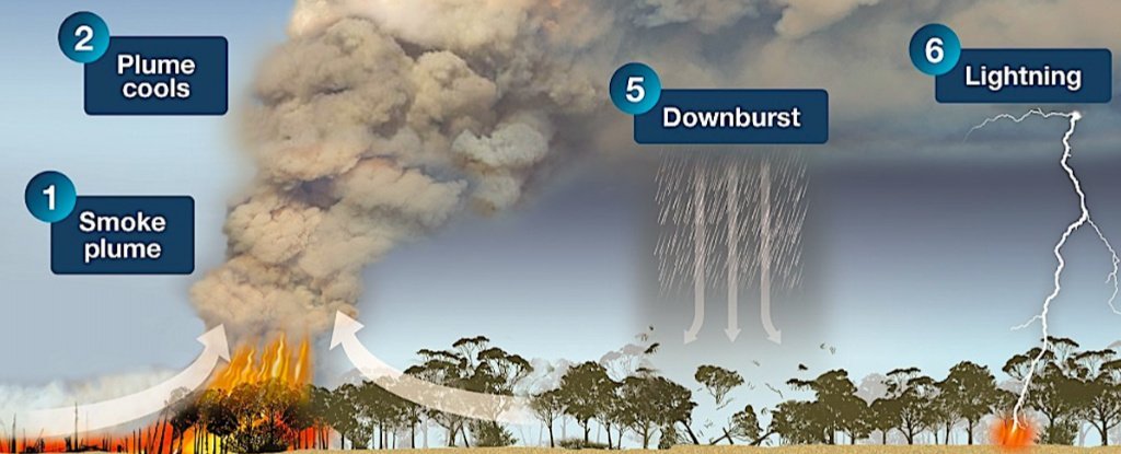
How these firestorms are generating:
Intense fires are generating smoke filled with hot air. As this hot air and smoke rises, low atmospheric pressure causes it to cool down and form clouds. The cloud plume can also scatter embers and hot ash over a wider area.
The water droplets in these clouds when begin to condense, it may lead to rain. However the “front” formed between the calm air away from the fire zone and a pyrocumulonimbus storm cloud is very sharp. This could lead to lightning and can start new fires.
CBS News meteorologist Jeff Berardelli fears of this explained weather phenomenon could be on the rise with the pace global climate is changing.
“It makes sense that as the air and ground warms and drys due to human-caused climate change, fires will become larger, burn longer and hotter,” Berardelli said. “Therefore, theoretically, pyrocumulonimbus clouds may become more common leading to more erratic fire behavior and more rapid fire spread.”